自然のこと22 [自然音と4K映像] 富士山(山梨)の早朝/2022.1.20/大寒

Nature Good Modeは、ご自宅のTV、PC、タブレット端末などを利用して、窓から大自然を眺めているかのようにご活用いただくことで、ご自宅と大自然を繋げる事が出来ます。あなたの行ったことがある景色、まだ見ぬ景色へ思いを巡らせ、時空間を超え風景に想いを馳せるひと時の旅をどうぞお楽しみください。
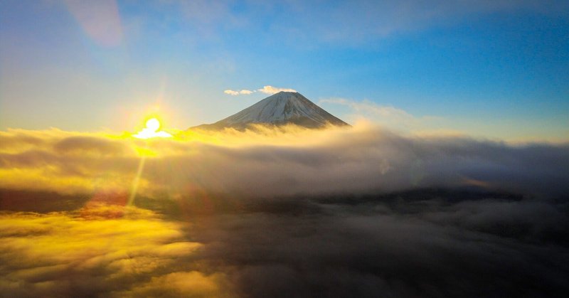
撮影現場は山梨県の本栖湖。廃校になった中学校のグラウンドからドローンを飛ばしての富士山空撮。地上はとても曇っていて富士山は全く拝めなかったが、雲から抜けると見た事もないほど美しい富士山が現れる。その存在感は圧倒的で、ドローンのコントローラの画面から眼を離す事ができずにあっという間の1時間14分を過ごす。雲が地上ギリギリまで低く降り、太陽が雲の上から昇る様は、寒さも極まり空気が極限まで締まったこの時期ならでは。ドローンがある時代だから拝める景色に息をのみ太陽と雲と富士山のコラボレーションに心から感謝を伝える。
▷Location Data:
緯度経度: 35° 28′ 4″N / 138° 36′ 28″E
カメラ角度: 150° NE
標高: 920m / 気温: -2℃ / 湿度: 56%
時空間: 2022.1.5. 06:50〜08:04 AM
The shooting site was Lake Motosu in Yamanashi Prefecture. Fuji by flying a drone from the ground of a closed junior high school. Fuji at all, but when we emerged from the clouds, we were greeted by the most beautiful Mt. Fuji. Its presence was overwhelming, and I couldn't take my eyes off the drone's controller screen for the next hour and 14 minutes. The clouds descend low to the ground, and the sun rises above the clouds, which can only be seen in this season when it is extremely cold and the air is extremely tight. In this age of drones, we were able to take in the view and gasp in appreciation for the collaboration of the sun, clouds, and Mt.Fuji.
▷Location Data:
Latitude and Longitude (DMS): 35° 28′ 4″N / 138° 36′ 28″E
Camera direction: 150° NE
Altitude: 920 m / Atmospheric temperature: -2℃ / Humidity: 56%
Spacetime: 2022.1.5. 06:50〜08:04 AM
▽ Support:
noteのサポート投げ銭大歓迎です!サポート頂いたお金は、ロケーションまでの交通費と撮影に必要な機材に使わせて頂きます!*Support will be used for equipment and travel expenses for the shoot.
■ PayPal.me
■ Amazon Gift Card: (nullgoodmode@gmail.com)
▽ Project:
■ Human Good Mode
■ Sake Good Mode
▽ Production Cooperation:
HELIO COMPASS 地球暦®
※Nature Good Modeは、HELIO COMPASS 地球暦を元に二十四節気のレコーディングを行っています。
最後までご覧いただきありがとうございます。
それではまた!
All for the next Dimension.
この記事が気に入ったらサポートをしてみませんか?