Michinoku Coastal Trail Basic hiking information

This article provides basic information on how to walk The Michinoku Coastal Trail. Based on my experience of walking the entire route twice both of south bound(SOBO) and north bound(NOBO).
(This article is based on information as of March 2024. The information provided is for reference only. Please do your own research, make a plan, and act at your own risk. Please note that I cannot be held responsible for any trouble or accidents that may occur as a result of using this information.)
(1) Official website and information center
The Michinoku Coastal Trail is a approximately 1,000km road that connects the Pacific coast from Hachinohe City, Aomori Prefecture to Soma City, Fukushima Prefecture.
As part of the recovery effort from the Great East Japan Earthquake, the Ministry of the Environment took the lead in creating this trail.
It is not only government but also private organizations and local residents to work together to develop the road.
Therefore, the opinions of local residents are reflected in route selection as much as possible.
It's only been five years since the entire line was opened, so there are many things that need to be improved and problems, but these hopes are reflected in the Trail Charter. Please read it once before you start walking.
The Michinoku Coastal Trail is not as difficult as a full-fledged mountain climb.
However, it would be difficult to take on the challenge without a plan.
On the other hand, The Michinoku Coastal Trail is not a continuous walk through nature and spectacular scenery.
Rather, it's a road to "Walk through the living spaces of people in the Pacific coast of north east of Japan''. For example, probably about half of the entire route is paved.
Preparation and manners are necessary to walk through Japanese living spaces. It's better to do enough research in advance, plan well, and walk with good manners. Try to minimize troubles as much as possible.
An example is where you can camp. Many locations along the route are privately owned or protected areas of national parks.
Therefore, there are limited places where camp are allowed.
Planning your trip to include accommodations and public transportation as much as possible, In order to interact with the locals.
Another example is "Alerts" information.
The Michinoku Coastal Trail is operated by the Michinoku Trail Club. It is essential to check the latest information on the Michinoku Trail Club website.
Information on detour routes and road closures is generally only posted on the Michinoku Trail Club website.
Be sure to read the "Alerts" before walking each time.
For inquiries from outside Japan, Natori Trail Center is the official information center for The Michinoku Coastal Trail mentioned above.
Also, when you are actually walking, there are information centers for each area along the route.
The information centers are as follows, starting from the south:
(1) Natori Trail Center
Information on the entire The Michinoku Coastal Trail and information south of Higashimatsushima City
And online-shop of Hiking Map books, Datebook, trail gear, etc…
(2) Minamisanriku Marine Visitor Center
Information from north of Ishinomaki City to south of Minamisanriku Town
(3) Goishikaigan Information Center
Information from north of Kesennuma City to south of Otsuchi Town
(4) Jodogahama Visitor Center
Information from north of Yamada Town to south of Iwaizumi Town
(5) Kitayamazaki Visitor Center
Information from north of Tanohata Village to south of Kuji City
(6) Tanesashi Coast Information Center
Information north of Hirono Town
However, the only facility specializing in The Michinoku Coastal Trail is the Natori Trail Center.
Each information center may or may not have a staff who specializes in The Michinoku Coastal Trail.
For example, there may be days when no one is available to answer questions that require detailed knowledge or skills.
Also, there are very few staff who can speak English each center.
Be careful about those things.
(2) Where to start and how to walk
You can walk The Michinoku Coastal Trail freely.
On The Michinoku Coastal Trail, a person who walks from the head point to the end point in one trip is called a through-hike.
Through-hiking the entire line is not an easy.
So, it's also a good idea to walk only attractive sections, or walk the same sections several times.
Through-hike is not better than section hike, or vice versa.
Choose the method that best suits your schedule, funds, physical strength, etc.
The trail has a long north-south distance, so the seasons change greatly.
If you're starting a through-hike in the spring, it's better to start in the warmer south.
If you're starting your through-hike in the summer or fall, it's better to head from the cooler north to the warmer south.
If you're going on a section hike, walking each section during the best season is recommended.
For example, famous cherry blossom viewing spots are around March to April, and azalea viewing spots are around May.
It's also a good idea to match the food seasonality of each region.
You should think carefully about which season you should walk in the following areas.
(1) Leeches inhabit the Oshika Peninsula and Kinkasan Island in Ishinomaki City.
So, if you want to avoid leeches, I recommend going this area between October and April.
(2) Urato Islands from Higashi Matsushima City to Shiogama City, there are no ferries in the winter. So you should walk during other seasons.
(3) Ogatsu Pass, located between Ishinomaki City and Onagawa Town, is also closed in winter, so a detour is required.
(4) There are also many other mountains that experience snowfall in the winter, such as Mt.Hashikamidake in Hashikami Town.
Therefore, you can start from a place that is easy to access or a place you want to walk to first, not only start from Hachinohe or Soma.
Don't think too much about direction and walking distance, too.
In addition to walking along the route, you are also welcome to take a detour if you see a place that interests you.
Also, things such as wanting to avoid the season when there are many insects, or wanting to have a good view of the sea, etc…, will also affect your choice of section.
Most comfortable times to walk are from around March to May and from around October to November.
If you don't use a tent, midwinter is good choice, too.
There are many sections where the leaves are falling and you can clearly see the ocean, and walking will your body temperature, so you don't have to worry about the cold as much.
However, you need to take precautions against the cold when taking a break and be careful about snow conditions.
(3) Basic gear
The gear for walking The Michinoku Coastal Trail should be based on light mountain climbing gear at an altitude of 500 to 1000 meters.
No serious mountain climbing equipment is required.
It is a good idea to base your gear on light mountain climbing and add resupply and camping gear.
The basic idea is not to choose items that are heavy.
There are many paved roads, so high-cut hiking shoes are not recommended.
Recommend mid-cut, lightweight trekking shoes or shoes for trail running.
It would be a good idea to have trekking poles.
It is convenient in Iwate Prefecture, which has many ups and downs. It also reduces fatigue even in Miyagi Prefecture, where the paved roads last for long periods of time.
It is also useful for removing spider webs in the summer.
In most sections of The Michinoku Coastal Trail, you can reach some kind of village or store after walking for about half a day.
Drink vending machines are also available in most sections (of course, there are some sections where there are none for an entire day).
It's always a good idea to have a few days' worth of food and water on hand, along with spares.
Especially when going on a through-hike, it is important to choose clothing that allows you to regulate your body temperature.
For example, from spring to summer, Iwate and Aomori prefectures experience cold foggy days called "Yamase".
When "Yamase'' comes, the high temperature can suddenly drop from 30 degrees to nearly 20 degrees.
Walking on a trail has a different purpose than mountain climbing.
The purpose of mountain climbing is to reach the top of a mountain.
But, the purpose of The Michinoku Coastal Trail is to continue walking for as long as possible.
If you want to continue walking for a long time, it is better to pack light.
There are many sections where you will have to walk through the city, so there are only a few sections where resupply is difficult.
Carefully consider the weight and necessity of your luggage so that you can continue walking for a long time.
Be flexible and try to reduce your luggage, such as using a zelt as a poncho.
But above all, you will be walking for long hours every day, so it is most important to choose gear that you are familiar with.
Many outdoor toilets in this region are closed during the winter.
Also, fishing ports often have toilets for fishermen, but they are often unavailable for use unless they are fishing.
However, in the summer, if you refrain from drinking water to reduce the number of times you go to the toilets, you may suffer from heatstroke.
Think about your physical condition and the weather that day.
Although you will walk in cool regions of Japan, it is not uncommon for daytime temperatures from early summer to early autumn to reach over 30 degrees Celsius.
Even if you try to rent a private house's toilet, you may not be able to find one for hours, so make sure you have a portable toilet with you.
Make sure to have some lights ready as well.
There are places where you have to walk through pitch-black tunnels.
Have a headlamp in addition to a regular light if possible.
You'll also need bug spray, a portable radio, and a bear bell.
Bears are often seen in Iwate Prefecture, but there have also been sightings in Miyagi Prefecture, from Kesennuma City to Minamisanriku Town, and in Aomori Prefecture.
Bears can be found even on paved roads, in residential areas, or in urban areas, regardless of the season, as long as they are close to mountains.
It's less common in winter, but it's not zero.
Be extremely careful throughout the year, especially north of Minamisanriku town.
Prepare a folding umbrella or poncho in case it rains.
It is a good idea to have something you can bivouac with, such as an aluminum sheet, for self-defense in case of an emergency such as a slip and fall.
It's helpful to have first aid kits, a sewing set with scissors, and safety pins, too.
Prepare enough food to last at least one day.
There are sections where there are no vending machines, no private houses, and no running water, so it may be a good idea to carry a few liters of water on your back, especially in the summer.
In the summer, most of the weight of your luggage will be drinks.
Camping supplies are difficult to obtain along the route.
There are very few outdoor specialty stores along the route.
There are home improvement stores in large cities, but the locations and number of items are limited.
Also, there are almost no camping supplies available in the winter.
Particularly in Iwate Prefecture, camping supplies are only available in a few large city centers such as Kuji, Miyako, Kamaishi, Ofunato, and Rikuzen-takata.
Gas cans (OD cans) and liquid fuel for alcohol stoves are especially difficult to obtain.
On the other hand, solid fuel is easy to find at 100-yen shops.
Of course, the Natori Trail Center also sells camping supplies and goods.
Also, since you often walk through residential areas, there are few places along the route where you can throw away your trash.
Please carry your own trash. And, ask for help at your accommodation or at a hiker support store, where should throw it away.
(4) Maps and Plans
Maps and GPS functions are essential, too.
Make sure buy "Hiking Map Books" available for purchase at the Natori Trail Center.
All sections are divided into 10 books, and each book is sold for 1,650 yen including tax.
If you buy a set of 10 books, you get a discount on the price of one book.
You can buy online at Natori Trail Center.
Until a few years ago, some maps were distributed for free by the Ministry of the Environment.
However, the free distribution has now ended.
Also, because the information on the map is old, the route may have changed or there may be places where it is impossible to walk.
It is recommended that you use Hiking Map Books as the basic and use the Ministry of the Environment map as supplementary information.
Additionally, for those who aim to complete the entire route, it would be helpful to have the separately sold "Data Book".
The "Data Book'' contains detailed information such as landmark names, distances between points, and altitudes for each location, so it is useful when making plans.
It is recommended that you walk The Michinoku Coastal Trail while referring to a map.
Also required that you are familiar with mountain climbing and have knowledge of outdoor activities.
Even if you have GPS, make sure you know how to read a paper map and use a compass.
For example, the knowledge that narrow spacing between contour lines on a map indicates a steep cliff or valley, and wide spacing between contour lines indicates a gentle slope.
In particular, the northern part of Iwate Prefecture, known as the "Alps of the Sea," has many steep ups and downs.
In order to allocate your pace, you need the ability to understand the terrain from map information.
GPS data is available on The Michinoku Trail Club website.
But, depending on the GPS application device, it may not be possible to tell the height difference.
In particular, the route in Iwate Prefecture has a large difference in elevation, so it is impossible to calculate the required time based on the speed you would walk on flat ground.
Also, if you plan to use GPS for a long time, you will need a spare battery.
Using GPS will consume more battery power.
Be sure to bring a paper map with you, as there is a possibility that the GPS will become unusable due to malfunction or low battery.
Please be careful about the route information for The Michinoku Coastal Trail posted on various mountain climbing applications. They are not official routes.
Those route is displayed independently by the operating company and may not be the correct route.
For example, old detours may still be displayed, forcing you to walk routes that you are no longer allowed to walk.
Please refer to it for reference only.
Once you have the map and data, use it to plan how you will walk.
When to walk, from where to where, in what direction, and at what pace.
How to get to the starting point and how to return from the goal.
Where will you stay nights?
Where to eat?
Know the transportation timetables (often only in Japanese).
If you miss your scheduled bus or train due to some kind of problem, when will the next train be?
For example, missing a train or bus can be a serious problem. The next train or bus may be several hours away, or may only come a few times a day.
Also, rushing to make it to your scheduled time increases the risk of getting injured or getting lost.
It is recommended to reserve accommodation in advance.
Many of the inn in this area always include dinner, may not allow you to stay without a reservation, and may not allow you to stay alone.
Many camping sites are closed during the winter.
On the other hand, on Saturdays and Sundays during high season, there are often no vacancies.
It is possible that you will not be able to find accommodation or a campsite on the day of your stay, so you need to plan accordingly.
There are only a limited number of accommodations that can provide English service and restaurants that can accommodate vegan meals.
It would be more appropriate to say that there are almost none, except in large cities.
In particular, people who require special dietary arrangements should consider preparing your own meals if possible.
Weather forecasts are also important. Rain, temperature, wind.
Some places may not be walkable when the waves are high or at high tide.
The ferry section may be canceled depending on wave and wind conditions.
In this region, the sun sets very early, except during the summer.
In winter, it is already start dark around 3pm.
In order to make a plan, you must also know yourself.
How many kilometers per hour can you walk?
Is it the same whether it's a paved road or a mountain road?
How far can you keep walking?
How does the speed change if you keep walking?
Your average speed will probably be different if you only walk 3km and if you keep walking 30km.
Walking on a trail requires a slightly different use of physical strength and mindset than mountain climbing.
South of Kesennuma City, most of the roads are flat and paved, so the distance you have to walk in a day gets longer.
Therefore, training by hiking in the mountains is of course preferable, but it is also important to train by walking on paved roads for long periods of time.
The name of the trail is "Coastal," but you don't just walk along the coast, you also walk in the mountains and around town.
First, get a "Hiking Map Books" and gather enough information before heading out.
Never make plans with naivety.
Also, please respect Japan's unique hiking and camping culture.
If you plan your trip with plenty of time and days, you will be able to enjoy sightseeing and interacting with local people even more.
(5) Sign and marker
Next, Introduce some examples of signs and markers.
The Michinoku Coastal Trail target to "feel and know about nature".
So, requires the ability to find and walk routes on your own, relying on maps, collected information, and signs.
You Can't be able to walk just by looking at the signs, but knowing them will help. Each sign has an official name (Type xxxx...etc), but here I will use the common name.
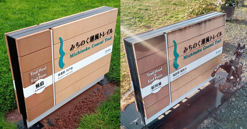
(1) Signboard with map
Located in front of major stations or at large branch points.
A map with a route around the area and nearby landmarks are displayed.
However, it is best not to calculate the time by simply dividing the number of kilometers by 4 km/h.
This is because distance does not reflect slope or elevation.
Naturally, the time required will differ between 5km on flat ground and 5km on all the way uphill.
The location of this sign is often not a place where you can get lost, so it's best to use it just to get a general idea of where you are.
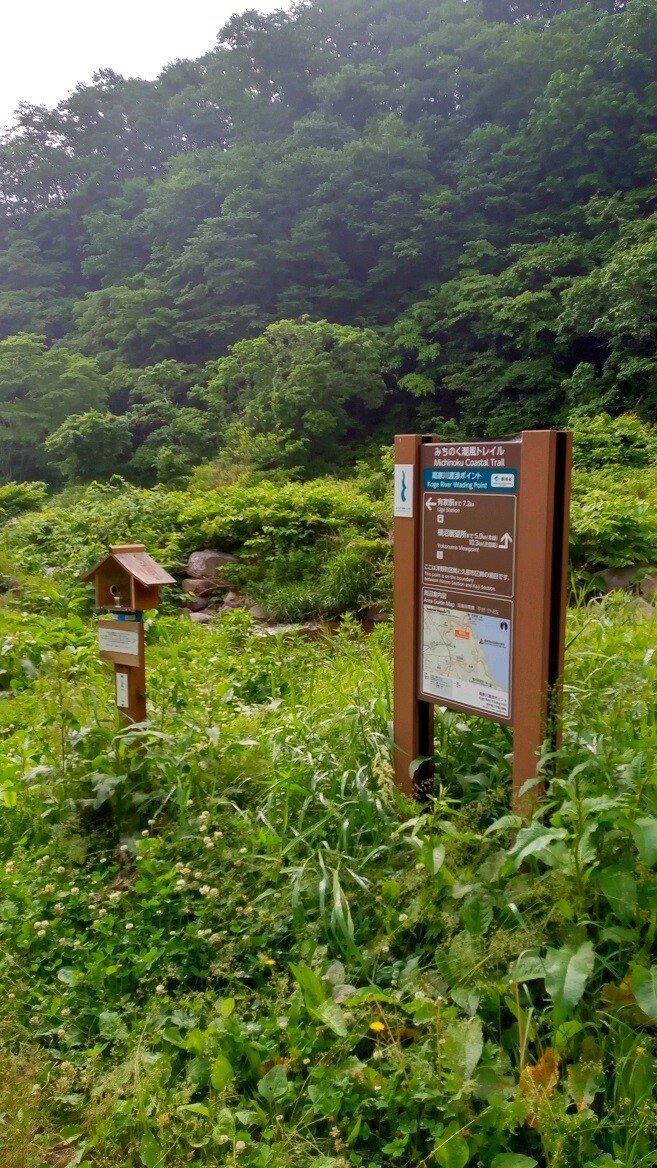
(2) "Feathered" type signs
Mainly located on larger bends and branch points.
It shows the names of landmarks approximately several kilometers away, along with the distance and direction to get there.
It helps you understand your current location, get an idea of your next destination, and if you have branch points, which direction to head in.
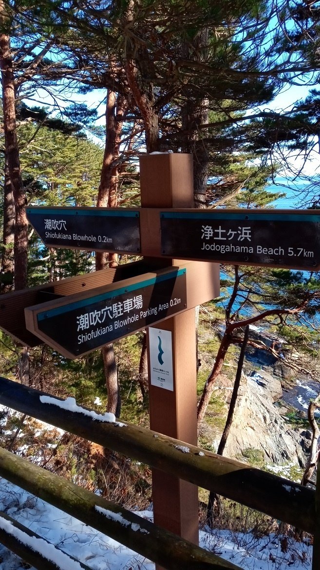
(3) Metal sign displaying current location, direction, and destination
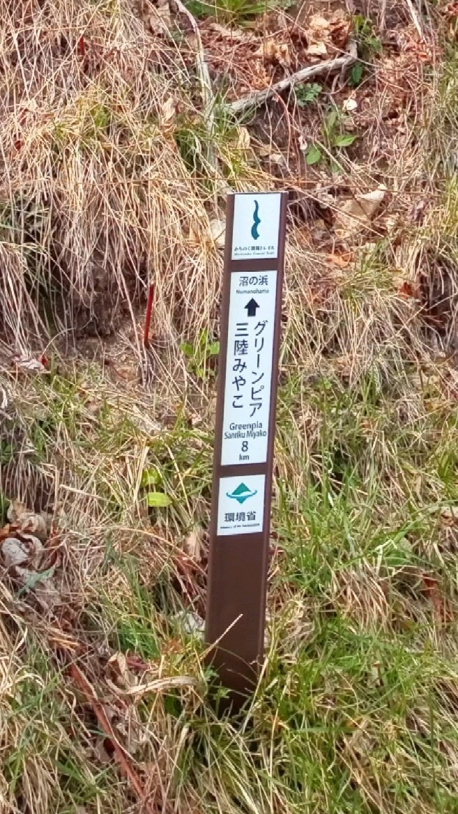
This is the latest type of sign that has been gradually increasing in Iwate Prefecture since around 2021.
You can also know the approximate place name of your current location, the direction you should go, and landmarks.
At major points there is also an indication of kilometers to the next point.
There are types that have both destinations written on the front and types that have destinations written in different directions on each side.
The second photo above is the type with destinations written on the front and back.
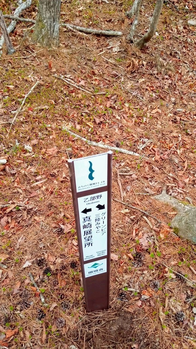
(4) Signpost with an arrow drawn at the top
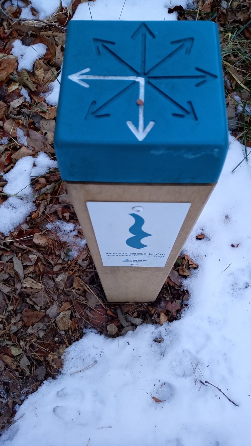
There is an eight-way arrow groove on the top of the post, with the arrow colored white only in the direction of the trail route.
They are often built in difficult-to-understand branch points and bends.
This post is useful for checking the route, but it may be difficult to find if it is located a little back from the route or if there is thick grass.
(5) White wooden pillar
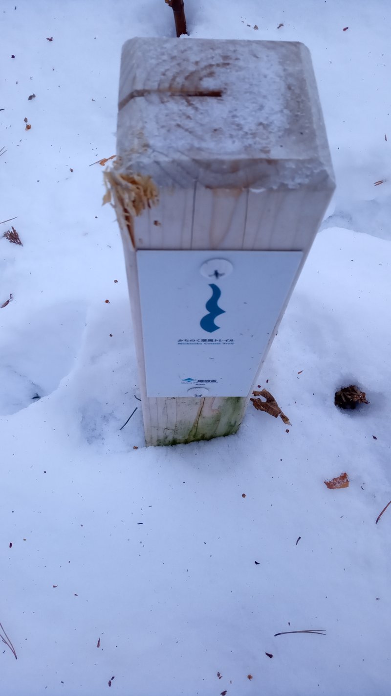
It's a small white wooden pillar built into the ground.
As you can see in the photo above, they often have scars caused by animals.
You may sometimes see them at branch points where it's easy to get lost, or along long stretches of road.
This will help you confirm that the place you are currently walking is on the route.
However, the single line at the top of this pillar has no relation to the direction of the trail route.
In the example photo above, the line is pointing to the left, but the route is not to the left.
It just shows that the location is not off the trail route.
Please make no mistake.
This is said to be a line to prevent the wood from splitting.
Arrow stickers may be added to these pillars, probably because it is easy to mistake them.
(6) Trail tape
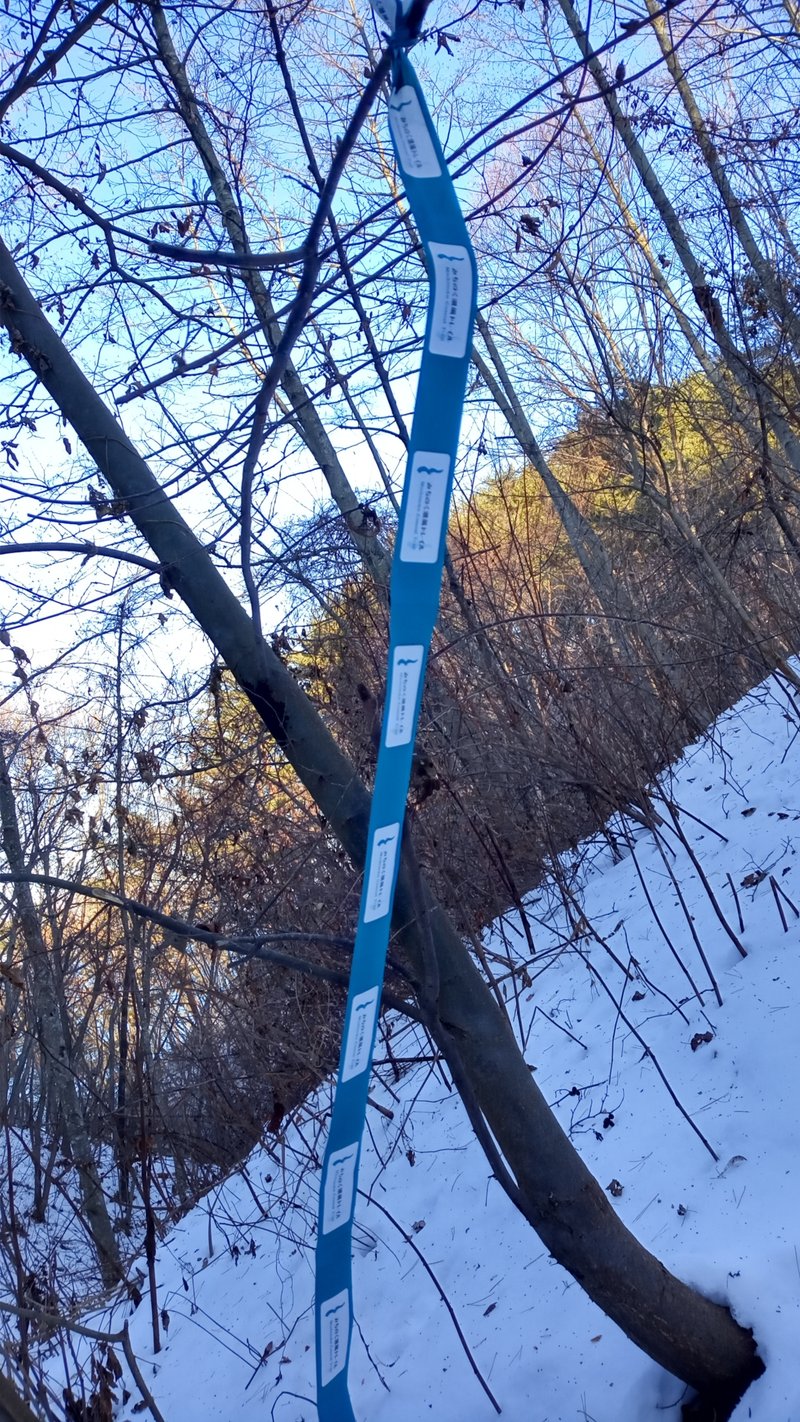
This tape is the simplest sign, but it gives you a great sense of security when you find it.
Usually wrapped around thick tree trunks, branches, or roadside fences on paved roads.
They often found in places where pillars cannot be erected even though the route is difficult to understand.
Therefore, they are often found just a little further down a branch points where it is easy to get lost, or in scree areas along streams.
If this tape, you will know that you are on the right route.
It's reassuring to find one when you have no choice but to walk through the woods or on a scree without a landmark.
There are often tapes wrapped overhead or in places high off the ground, so if you are unsure about the route, it is a good idea to carefully observe your surroundings.
If you look carefully at a distance of several dozen meters, you will often see tape hanging down.
There are some things you need to be careful about tape.
Various other tapes can be found in the forest.
Pink, light blue, or yellow.
They do not refer to trail routes.
For example, it may be used to show the work path of a forestry worker.
There are sections where such roads and trail routes match, but there are also sections where they do not.
So, if you follow those tapes, you may get lost.
It is important to follow only the tapes of the Michinoku Coastal Trail.
(7) Detour sign
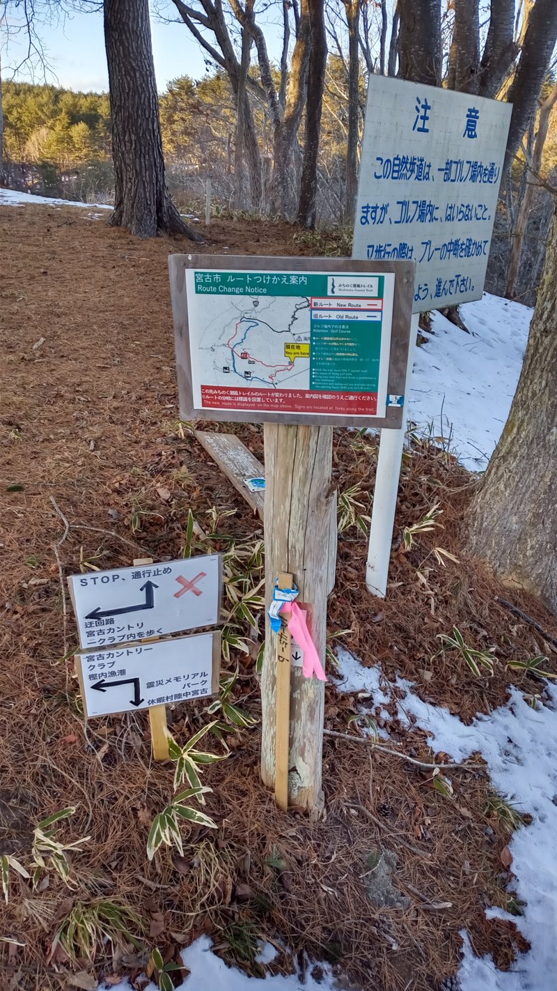
The route of the Michinoku Coastal Trail frequently changes due to disaster recovery construction and other reasons.
Signs are usually erected at the entrance and exit of such detours.
Detour information will also be posted on the Michinoku Trail Club website.
However, mainly after stormy weather, even though signs are not erected in time, there are times when roads are closed or clearly impossible to walk due to fallen trees, landslides, rising water in streams, etc.
Even on paved roads, detours may occur due to road construction without prior information.
Also, while walking along a detour, there are often few signs indicating the route, so if you see a detour sign, it's a good idea to take a photo of the map there.
It is important to take actions that are tailored to the actual situation of the location.
(8) Hiker count counter
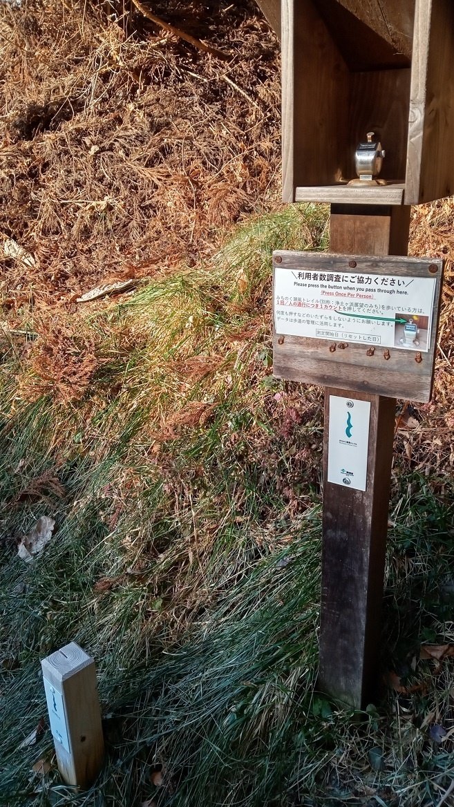
This is a manual counter to check the number of hikers actually walking.
Press the counter only once as you pass.
Currently, it is mainly located in the Iwate and Aomori prefectures.
The numbers are reset approximately every month.
(9) Other signs
In addition to the above, there are many other variations, such as signs installed by each municipality and hand-painted signs installed by local organizations and residents.
Although they are often only in Japanese, signs for national parks and nature parks are often helpful.
(6)Public transportation
The public transportation that can be used is mainly trains and buses.
In many sections, trains or buses run close to the route, so it's easy to use your accommodation as a base and walk in smaller sections.
However, in most areas, the frequency of trains and buses is very low. Sometimes it's one every few hours.
Be sure to understand the timetable in advance and walk with plenty of time to spare.
Here are some examples of convenient transportation.
In Aomori Prefecture : JR Hachinohe Line.
In Iwate Prefecture : Sanriku Railway, Iwate-Kenpoku Bus, and BRT Ofunato Line.
In Miyagi Prefecture : BRT Kesennuma Line, JR Ishinomaki Line, JR Senseki Line, Sendai Airport Access Line, JR Joban Line, MIYAKOH bus.
In Fukushima Prefecture : JR Joban Line.
Just by using these, you can walk through quite a lot of sections.
It may be helpful to check the following transportation in specific area.
However, special care must be taken when using these transportation.
For example, they may run very infrequently, require reservations, or only run on weekdays.
Also, most of the information is only in Japanese.
Fudai village : village minibus.
Tanohata village : sightseeing taxi.
Minamisanriku town : town citizen bus.
Ishinomaki city : kitakami district resident bus, ogatsu district resident bus.
Additionally, ferries are included in the routes for the following islands in Miyagi Prefecture.
Kinkasan island
Ajishima island
Tashirojima island
Urato islands
Kinkasan island's ferry only runs on Sundays.
On other days of the week, you will need to reserve a chartered ferry, except for occasional temporary ferries.
Regular ferries are available for Ajishima Island and Tashirojima Island.
Reservations are not required, but please plan ahead as there are only a few ferries and cancellations are likely due to bad weather.
The route from the Urato Islands to Shiogama Port is a regular route, and although there is a fee, reservations are not required.
The route from the Urato Islands to Miyatojima island in Higashimatsushima City is a dedicated ferry for the Michinoku Coastal Trail.
Reservations are required at Natori Trail Center at least 5 days before boarding. Pay the fare in cash when boarding the ferry.
The times are set times twice a day.
Additionally, ferries do not operate from November to March.
Within the Urato Islands, ferry between islands is free.
If the ferry is not coming, you can call the cell phone displayed in the waiting room and the ferry will arrive in about 5 to 10 minutes.
Please note that in many cases, payment must be made in small change in cash for transportation such as trains, buses, and ships.
Always have plenty of coins and 1,000 yen bills on hand.
10,000 yen and 5,000 yen bills may not be usable.
The first thing to do is to get a "Hiking Map Books".
It has a comprehensive collection of information you need for walking, such as an overview of each region, climate, and transportation contacts.
(7) Community, Supporters
The most active place for information exchange in the Michinoku Coastal Trail community is the online Facebook group.
There are both Japanese and English groups.
In both cases, not only hikers who are just starting out but also locals and hikers who have already finished the entire route, so it is very easy to ask questions.
English:
Japanese:
Once you actually start walking, try to take advantage of the trail supporter shops and facilities along the route as much as possible.
You can receive a variety of support, including shops that welcome hikers, facilities where you can pitch a tent, and staff who are themselves hikers.
This article is free, but if you would like to support the author, you can pay 300 yen below (No new sentence below, There's just a payment button).
ここから先は
¥ 300
この記事が気に入ったらサポートをしてみませんか?