【VPS比較】AR Localization Technology Overview

Hi, I am a VR/AR engineer Matt (@mechpil0t) working in The Designium’s Tokyo office.
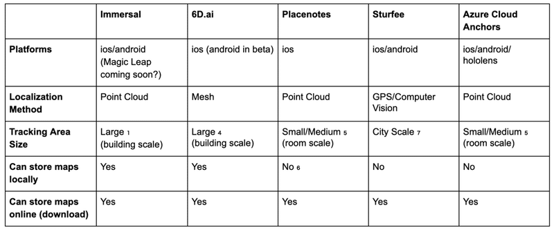
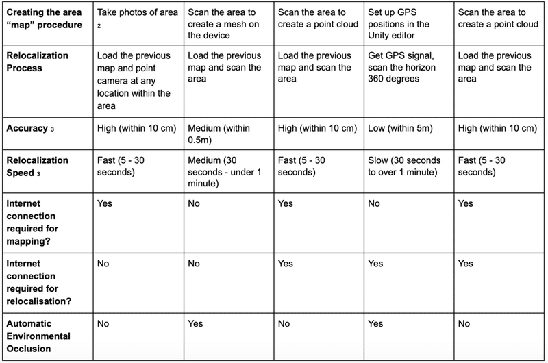
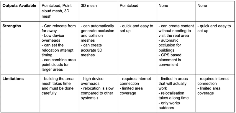
Recently I have been experimenting with Immersal and Sturfee to create larger scale AR content. In the following chart I compare some of the core functions, dependencies, and details of these systems with systems I have experimented with in the past.
All platforms use ARcore/ARkit for device tracking after localization.
In testing Immersal appears to be the strongest candidate for larger-scale AR applications, the maps are easy to work with which makes placing AR content simple and localization is fairly efficient, effective, and robust.
Comparison chart of VPS
₁ a whole cinema is one of their examples
₂ pictures are uploaded to an online point cloud builder
₃ from my experience
₄ they claim huge areas will be available but only have shown smaller scale demos
₅ Placenote website: “recommend for the best performance that the area scanned is within about 1200sqft” ~ 100 m2
₆ I don't think so - I cannot find examples of local storage
₇ in theory
Platforms: Which devices/OS are supported by this technology.
Localization Method: How does this technology localize.
Automatic Environmental Occlusion: Does the technology automatically provide a mesh to occlude AR content.
Outputs Available: What resources can we get from the system to aid in development.
Immersal
One of the benefits of Immersal is the UX, especially when we consider users who are unfamiliar with AR applications. All other technologies featured in the above chart require the user to scan the AR area in some way. In my experience, Immersal on the other hand can relocate by simply pointing the camera at a mapped area. I expect this would make the UX of relocalization much better for users unfamiliar with AR in general.
While Immersal does seem like the strongest candidate for large scale AR, the technology does have some limitations in terms of map creation, environmental occlusion, accuracy and map file sizes.
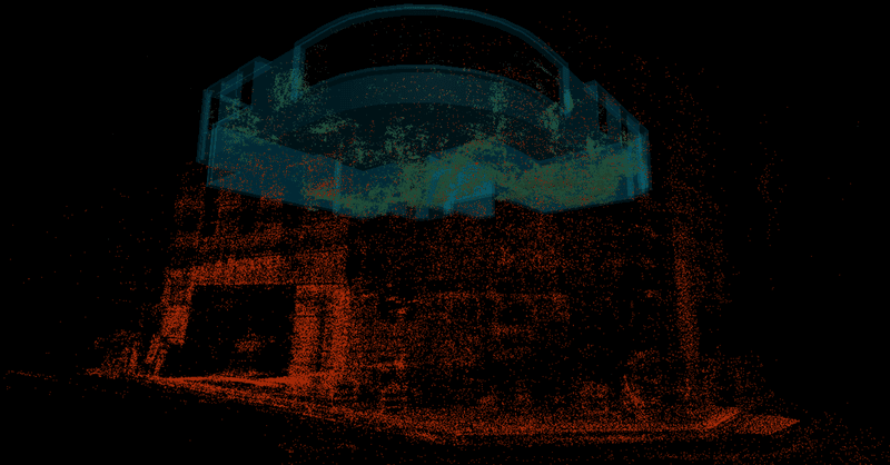
Map creation is done by taking many overlapping pictures of an environment using the Immersal mapping application. This must be done in real time (i.e. you cannot just upload a collection of images) and the mapping application is a little unresponsive so it can be very slow/frustrating work. In addition, the mapper is limited to around 100 images, meaning for large areas you need to make multiple maps and stitch them together.
Environment occlusion can be achieved by downloading the automatically generated environmental map meshes from the Immersal dev portal. These are very hi-poly and must be manually placed in Unity, making environmental occlusion meshes a chore to implement. However, because Immersal uses unmodified ARFoundation, functions from AR Foundation can be easily used along with Immersal, for example occlusion plane detection.
The accuracy of Immersal is usually good, however because the system is constantly checking the environment, if part of the environment has changed (e.g. chairs and tables moved in an office) the system can become confused and misplace AR content.
Immersal allows users to download maps so they don't have to be stored on the device. This would allow developers to change/update maps without needing to update the application itself. However at the moment map file sizes are a little large and so downloads can take between 10-30 seconds (in my testing). This is an unusable amount of time.
The Immersal devs have informed us they will be reducing the file sizes considerably, so hopefully this problem will be solved in future.
6D.ai vs Immersal
6D.ai claims many similar features to Immersal, however it is functionally and practically (in my experience) very different. In practical terms I have found 6D.ai to be slower and less accurate at relocalization, however the environmental meshing is convenient for environmental collision and occlusion.
What the immersal devs say
(from their Discord channel):
“well, compared to 6d.ai we use a different approach in generating the maps altogether. - 6d.ai does the mapping on-device which limits the range for map generation. You can't map areas further away. From the videos, it looks like the range is a few meters. - we can use much more compute resources for the mapping (on the cloud) while still keeping the app lightweight. with 6d.ai you still need to "pre-scan" locations. The process uses so much compute resources on current devices, that running other stuff on top of mapping is not advised https://www.6d.ai/faq/ - we already have android support out, 6d.ai doesn't Now, how does this affect indoor navigation apps? - Mapping large locations takes more time as you need to really go through every surface pretty close by - I suspect the localization won't work from as far away as ours does”
Editorial Note 編集後記
広報のMarikoです!今回は、MattがたくさんあるARクラウドやVPSサービスを比較検証した結果をまとめてくれました✨一長一短ではありますが、現状ではImmersalが一番良さそうですね!みなさん参考にして頂けたでしょうか?デザイニウムではPlacenoteを使った展示の実績もあったり、R&D部でもARコンテンツを開発してるメンバーもいるので、是非サイトやnoteマガジンもチェックしてみてくださいね❗
The Designium.inc
The Designium interactive site
YouTube Channel
Facebook
Twitter
この記事が気に入ったらサポートをしてみませんか?